How Airace One Simplifies GPS Tracking and Survey Analysis for Professionals
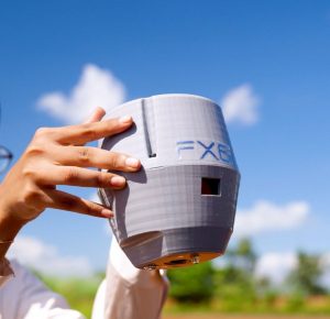
What is Airace One?

Airace One is a powerful mobile application designed to simplify GPS tracking and survey analysis. It effortlessly connects with RTK GNSS receivers, offering experts a complete solution for precise positioning, data gathering, and evaluation. Airace One streamlines workflows, and improves efficiency. Also, it enhances the accuracy of your field operations. With Airace One, you can collect high-quality geospatial data faster and more reliably than ever before.

Why do you need Airace One?

Airace One is essential for professionals who require precise location data and efficient workflows. It removes the necessity for manual data input and minimizes the chance of mistakes. This results in enhanced efficiency and better data accuracy. Airace One streamlines operations by automating data collection and analysis. This frees up valuable time for professionals to focus on strategic decision-making.

By integrating seamlessly with existing systems, Airace One ensures a smooth and efficient transition. This minimizes disruptions to daily operations.

Is it mandatory to subscribe to the Airace One mobile application if you purchase the RTK receiver?

No, subscribing to the Airace One mobile application is not mandatory if you purchase an RTK receiver. However, utilizing the app significantly enhances the functionality and capabilities of your RTK receiver.

The Airace One app provides real-time data visualization, job management tools, and access to advanced features like corrections services and remote support, optimizing your workflow and improving accuracy.

While using the RTK receiver without the app is possible, you may miss out on crucial features and limit the overall performance and efficiency of your surveying operations.

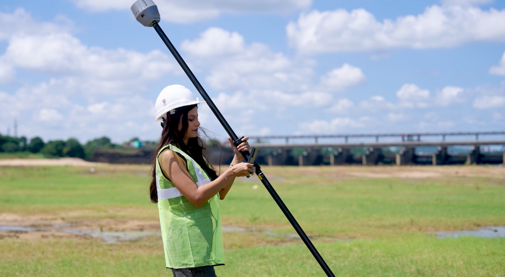
How is the RTK receiver connected with the Airace One mobile App?

dgps

The RTK receiver connects to the Airace One mobile app via Bluetooth or Wi-Fi. This enables real-time data transfer and allows the app to access precise positioning data from the receiver.

The Airace One app then utilizes this precise positioning data for various applications, such as asset tracking, field service management, and location-based services.

This integration streamlines workflows and improves operational efficiency. Also, it enhances data accuracy for businesses and individuals.

  1. Increased Productivity: Streamline your fieldwork and reduce time spent on manual tasks. Improve team collaboration with real-time data sharing and gain valuable insights through automated reporting. Boost overall efficiency and make informed decisions faster than ever.
  2. Enhanced Accuracy: With RTK GNSS integration, you can attain centimetre-level accuracy. This advanced technology ensures precise positioning for applications such as surveying, construction, and autonomous vehicles. With real-time corrections, RTK GNSS enhances the reliability and efficiency of location-based services in demanding environments.
  3. Improved Data Quality: Collect and manage high-quality survey data easily. Airace One offers seamless integration with various data collection tools, ensuring accuracy and reliability. Effortlessly organize and analyze responses to generate actionable insights that drive informed decision-making.
  4. Enhanced Collaboration: Exchange information and work effortlessly with teammates and customers. Streamline communication to ensure smooth collaboration and foster strong relationships. Leverage efficient tools and platforms to enhance productivity and deliver results with precision.

How does the Airace mobile application help industries with GPS Mapping & Surveys?

Airace One empowers various industries with its GPS mapping and survey capabilities.

  1. Land Surveying:

Airace One assists land surveyors in accurately mapping property boundaries, calculating areas, and generating detailed topographic maps.

It streamlines data collection with high-precision GPS and advanced imaging technology. This reduces manual errors and saves time. Additionally, its user-friendly interface simplifies complex surveying tasks, making it accessible for professionals at all experience levels.

  1. Building Surveyors:

Building surveyors can utilize Airace One to precisely measure building dimensions, create as-built drawings, and assess building conditions. Additionally, Airace One streamlines the documentation process by generating accurate 3D models for renovation and restoration projects. Its advanced scanning capabilities also help identify structural issues and ensure compliance with safety standards.

  1. Home Surveyors:

Home surveyors can leverage Airace One to conduct accurate property surveys, determine property lines, and assess site suitability for construction.

Additionally, its advanced mapping features enable detailed land analysis and efficient documentation. The device’s portability and real-time data processing streamline on-site decision-making for surveyors.

  1. GPS Mapping:

Airace One facilitates GPS mapping by enabling real-time location tracking, mapping, and data collection. This is crucial for various applications, such as asset tracking, field data collection, and route mapping.

It enhances operational efficiency. Also, it provides accurate geospatial insights and optimizing resource allocation. Additionally, its seamless integration with analytics tools allows for informed decision-making and strategic planning.

  1. Topographic Survey:

Airace One assists in topographic surveys by enabling the collection of elevation data, and the creation of contour maps. Also, it enables the generation of digital terrain models.

It also enhances accuracy and efficiency in mapping large or inaccessible areas. This reduces the time and cost of traditional surveying methods. Additionally, Airace One supports advanced geospatial analysis. This helps in better planning and decision-making for construction and infrastructure projects.

Features of Airace One Mobile Application

  1. Universal RTK GNSS Compatibility: Airace One seamlessly connects with Airace RTK receivers and other RTK GNSS receivers, regardless of brand. Airace One offers high-precision positioning data. This enables accurate mapping, surveying, and construction applications. Seamless integration with various GNSS receivers ensures compatibility and flexibility for diverse project needs.
  2. Surveyor Tools: Airace One simplifies tasks for building surveyors, home surveyors, and those calculating home survey costs, ensuring precise data and streamlined workflows. It enhances accuracy in property assessments and accelerates project completion times. With user-friendly tools and advanced analytics, professionals can make informed decisions effortlessly.
  3. RTK GNSS Support: Airace One seamlessly integrates with RTK GNSS receivers. This integration enables centimetre-level accuracy. This ensures precise positioning and data collection. It enhances operational efficiency across various surveying and mapping applications. Users benefit from reliable performance even in challenging environments.
  4. GPS Mapping & Tracking: This solution leverages high-precision GPS technology. It enables accurate location tracking, mapping, and data collection. These operations occur in real time. The system ensures seamless integration with various analytical tools for enhanced decision-making. Its scalability allows deployment across diverse environments and industries.
  5. Coordinate System Support: This app permits you to work seamlessly with a variety of coordinate systems. These include WGS84, UTM, and local grids. This ensures data compatibility and interoperability between different projects and platforms.
  6. Survey Tools: Access a comprehensive range of survey tools, including:
    • Stakeout: Accurately stake out points, lines, and areas on the ground.
    • Distance Measurement: Calculate distances between points with high precision.
    • Area Calculation: Calculate areas of parcels, plots, and other features.
    • Elevation Measurement: Determine elevations and create digital terrain models.
  7. Real-Time GPS Mapping: Utilize advanced GPS technology for precise location monitoring and real-time mapping during field activities. This guarantees no detail is overlooked. Moreover, this ensures seamless navigation and enhances operational efficiency in dynamic environments.
  8. Topographic Survey Support: Create detailed topographic maps with precision tools that allow accurate data collection for terrain modeling, contour generation, and more. These maps enhance project planning by providing critical insights into elevation changes and landform characteristics.
  9. Coordinate System Compatibility: Operate effortlessly with various systems, such as WGS84, UTM, and local grids, guaranteeing smooth data sharing and integration across projects. This versatility enhances collaboration and ensures accuracy in geospatial analysis and decision-making.
  10. Data Collection & Management: The app efficiently collects, stores, and manages survey data. You can easily export this data in various formats, including CSV and DXF. This seamless integration allows you to use the data with other software and GIS platforms.
  11. GIS Tools: Enhance your workflow with basic GIS tools, such as:
    • Map Display: View and analyze maps and imagery.
    • Feature Creation: Generate and modify points, lines, and shapes on the map.
    • Attribute Data: Attach attributes to features for enhanced data management.
  12. Geotagged Photos: Capture and store geotagged photos directly within the app. Associate photos with specific survey points or features for enhanced data visualization and reporting. Enable easy photo retrieval and sharing for streamlined collaboration and decision-making.
  13. Report Option: Generate comprehensive reports directly within the app. Include survey data, maps, images, and notes to create professional reports for clients or project documentation. Easily export reports in multiple formats for seamless sharing and collaboration.

Benefits of Airace One Mobile Application

  1. Increased Productivity: Streamline your fieldwork and reduce time spent on manual tasks. Improve team collaboration with real-time data sharing and gain valuable insights through automated reporting. Boost overall efficiency and make informed decisions faster than ever.
  2. Enhanced Accuracy: With RTK GNSS integration, you can attain centimetre-level accuracy. This advanced technology ensures precise positioning for applications such as surveying, construction, and autonomous vehicles. With real-time corrections, RTK GNSS enhances the reliability and efficiency of location-based services in demanding environments.
  3. Improved Data Quality: Collect and manage high-quality survey data easily. Airace One offers seamless integration with various data collection tools, ensuring accuracy and reliability. Effortlessly organize and analyze responses to generate actionable insights that drive informed decision-making.
  4. Enhanced Collaboration: Exchange information and work effortlessly with teammates and customers. Streamline communication to ensure smooth collaboration and foster strong relationships. Leverage efficient tools and platforms to enhance productivity and deliver results with precision.

Conclusion

In conclusion, Airace One is a valuable tool for GPS tracking and survey analysis professionals. Its intuitive design, robust capabilities, and smooth compatibility with RTK GNSS receivers make it an essential tool for boosting efficiency, enhancing precision, and optimizing processes.

With its user-friendly interface and advanced features, it simplifies complex tasks. Also, it enables users to achieve reliable results faster. The ability to seamlessly integrate with various systems further elevates its functionality. This makes it a top choice for professionals in the field.

Leave a Reply