

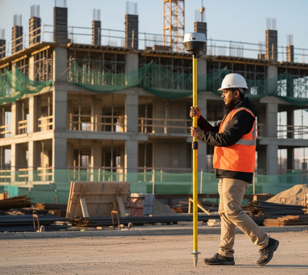
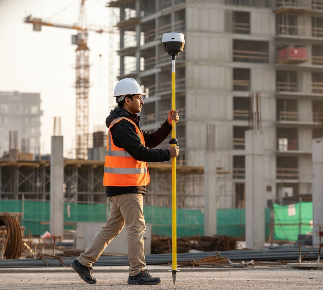
Compact size and
lightweight
Designed with lightweight and
compact features, making them highly
portable and easy to use without the
need for bulky and cumbersome
equipment
Millimeter
accurate data
Intelligent processing techniques include
factors such as signal quality, atmospheric
interference, and satellite geometry to
provide highly accurate and reliable
position information
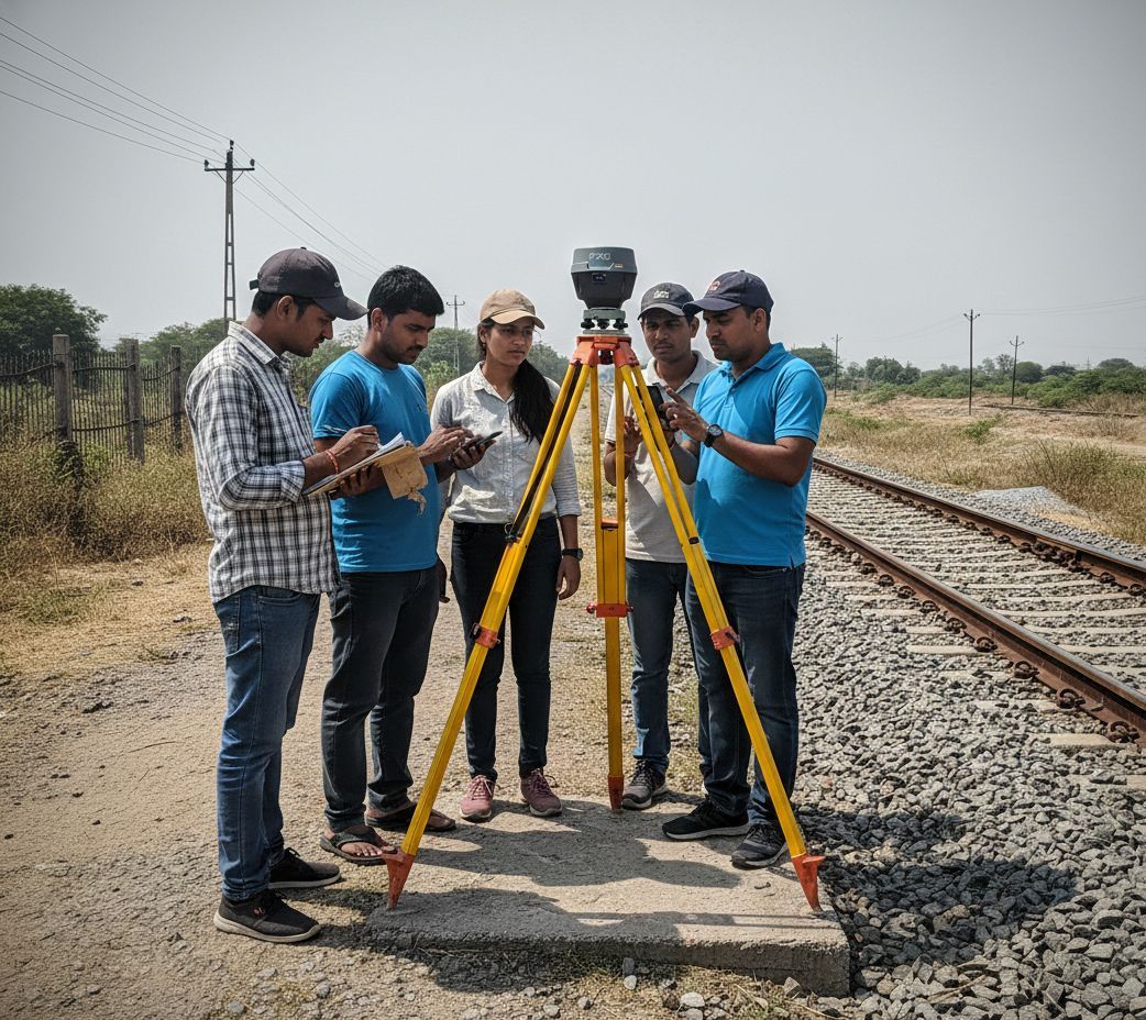
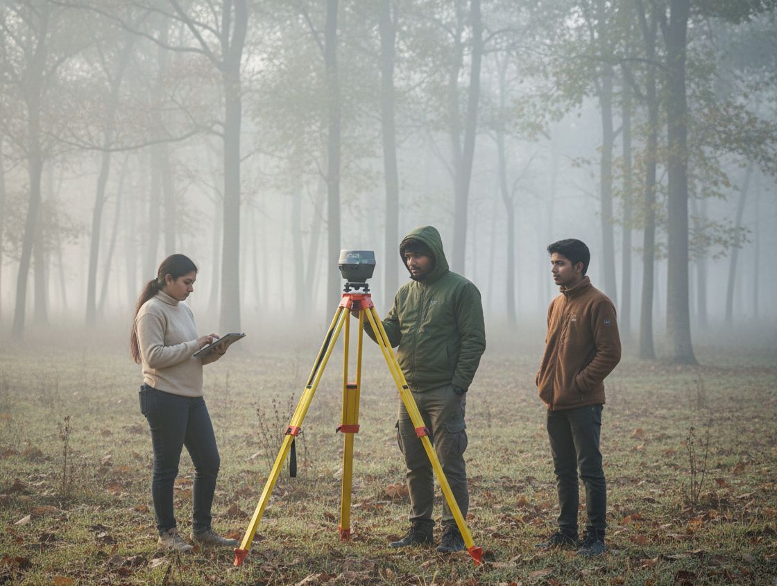
Anyone on the
team can use RTK
The interface is designed to be
intuitive and easy to navigate with
clear and concise instructions.
Anyone can use our GNSS receiver
without any training
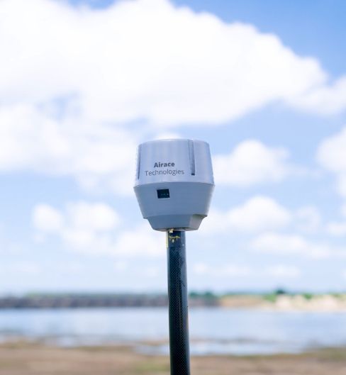
With in-built
Laser Distance Module
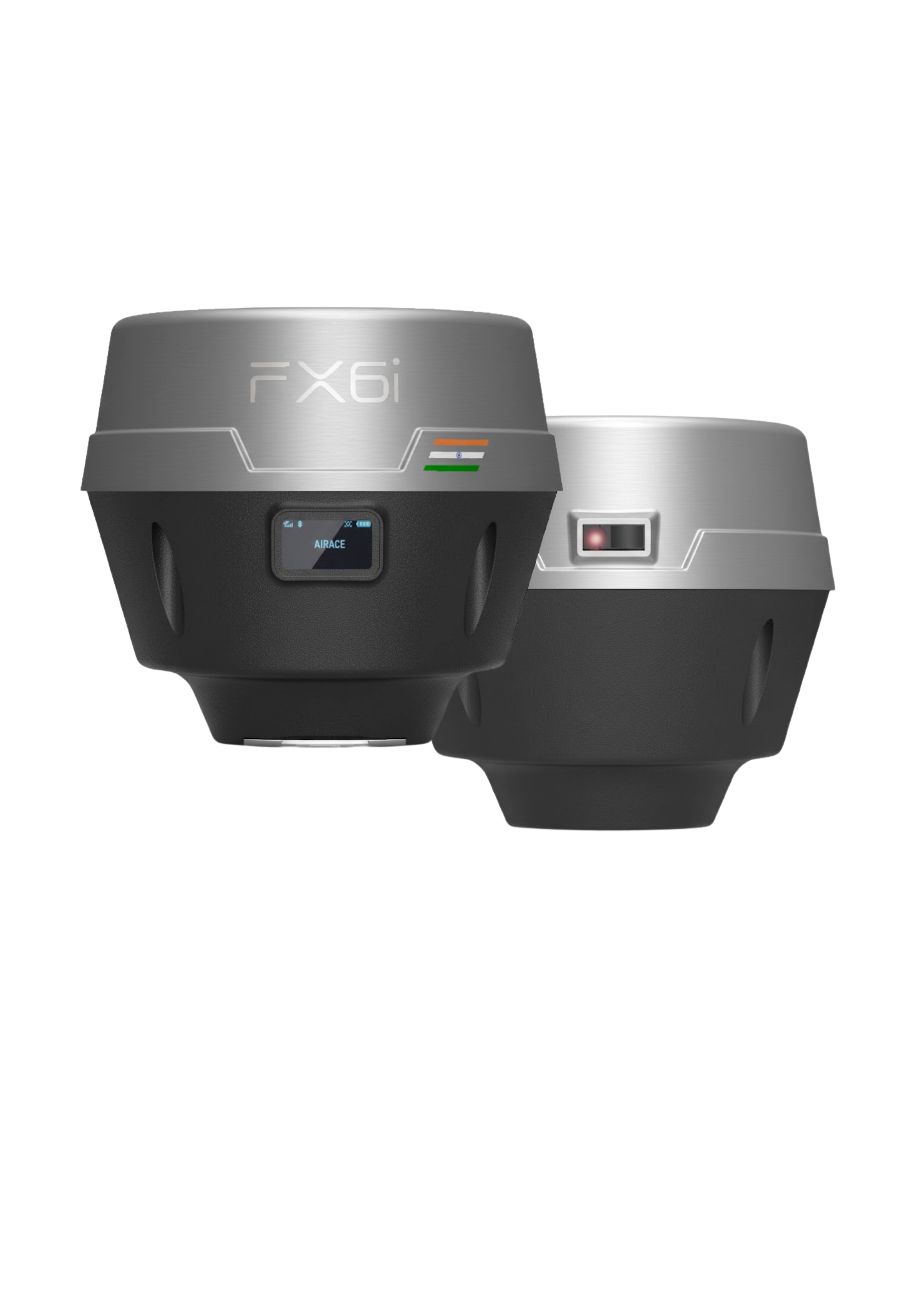
The Airace FX6i Receiver features an in-built laser
distance module designed to overcome the
limitations of traditional satellite positioning,
particularly in challenging environments, thereby
significantly improving accuracy, reliability, and
versatility.
Compact size and
lightweight
Designed with lightweight and
compact features, making them highly
portable and easy to use without the
need for bulky and cumbersome
equipment
Millimeter
accurate data
Intelligent processing techniques include
factors such as signal quality, atmospheric
interference, and satellite geometry to
provide highly accurate and reliable
position information
Anyone on the
team can use RTK
The interface is designed to be
intuitive and easy to navigate with
clear and concise instructions.
Anyone can use our GNSS receiver
without any training
LASER
The Airace FX6i Receiver features an in-built laser
distance module designed to overcome the
limitations of traditional satellite positioning,
particularly in challenging environments, thereby
significantly improving accuracy, reliability, and
versatility.
EASY SETUP
Set up in just few simple steps
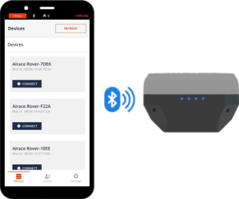
1. Enable Bluetooth

2. Configure Details

3. Collect your points
EASY SETUP
Set up in just few simple steps
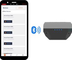
1. Enable Bluetooth
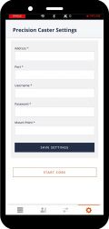
2. Configure Details

3. Collect your points
AIRACE ONE
Surveying with Airace One
With Airace One, quickly set up the GNSS receiver and start work collecting or staking out points.
The app supports thousands of coordinate systems and is available on multiple platforms.
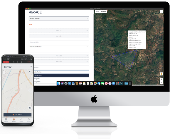
Point Collection : Save points and export data to CSV
You can record millimeter-precise coordinates for each point. The app can export and import data in the CSV, DXF, KML and Shapefile formats used by CAD, GIS, and most other professional survey software.
You can also share collected data using mail, or a smart messaging system from your phone.
Stakeout
Stakeout can be used to find the exact locations of points.
They can be collected in the Airace One app or imported from other CAD or GIS software.
Coordinate systems based on
WGS84
NAD83
GDA2020
NAD27 (CONUS)
European 1950
Tokyo
South American 1969
Australian Geodetic 1984 (AGD84)
Indian (Bangladesh/Thailand)
— and many more.
AIRACE ONE
Surveying with Airace One
With Airace One, quickly set up the GNSS receiver and start work collecting or staking out points. The app supports thousands of coordinate systems and is available on multiple platforms.
Point Collection : Save points
and export data to CSV
You can record millimeter-precise coordinates for each point. The app can export and import data in the CSV, DXF,KML and Shapefile formats used by CAD, GIS, and most other professional survey software. You can also share collected data using mail, or a smart messaging system from your phone.
Coordinate systems based on
WGS84
NAD83
GDA2020
NAD27 (CONUS)
European 1950
Tokyo
South American 1969
Australian Geodetic 1984 (AGD84)
Indian (Bangladesh/Thailand)
— and many more
Stakeout
Stakeout can be used to find the exact locations of points. They can be collected in the Airace One app or imported from other CAD or GIS software.


Weight: 479 g
Dimensions: 119.5 mm (H) X 138.5 mm (W) X 138.5 mm (L)
Small, compact, and lightweight.
Can be carried anywhere with ease.
-20 to +60 °C
(-4 to 140 °F)
Our GNSS receiver works in extreme conditions,
from the coldest winters to the hottest summers.
and can survive and work in both dusty and humid
environment.
Reliable Battery
20 hours of work
A day of work for just a few hours of
charging. It can be also charged anywhere
from any USB port or power bank.
10000 mAh Li-Ion battery
Reliable and lightweight battery
that provides power in any
working condition.
2000+ cycles
of charging and discharging
while maintaining original
capacity.
DESIGN
Compact and Rugged

Weight: 450 g
Dimensions: 165 mm x 100 mm
x 100 mm
Small, compact, and lightweight. Can be carried anywhere with ease.
-20 to +60 °C (-4 to 140 °F)
Our GNSS receiver works in
extreme conditions, from
the coldest winters to the hottest
summers.
Weatherproof
Airace FX6i is IP67 Water and Dust Proof
and can survive and work in both dusty and humid
environment.
Reliable Battery
20 hours of work
A day of work for just a few hours of
charging. It can be also charged anywhere
from any USB port or power bank.
6500 mAh Li-Ion battery
Reliable and lightweight battery that
provides power in any working condition.
2000+ cycles
of charging and discharging while
maintaining original capacity.
REVIEWS
Our customer's reviews
Highly accurate
We have been extremely impressed with its performance. The system is highly accurate, providing millimeter level precision that has greatly enhanced our surveying capabilities

Highly accurate
We have been extremely impressed with its performance. The system is highly accurate, providing millimeter level precision that has greatly enhanced our surveying capabilities
Quick Setup and very Intuitive
The user interface is intuitive and easy to use and allows for quick setup. We especially like the portability and lightweight design of the system, which makes it easy to take with us into the field.
Quick Setup and very Intuitive
The user interface is intuitive and easy to use and allows for quick setup. We especially like the portability and lightweight design of the system, which makes it easy to take with us into the field.
Responsive Customer support
Customer support has been extremely helpful and responsive, providing us with prompt assistance whenever I've had questions or needed help troubleshooting any issues.
Responsive Customer support
Customer support has been extremely helpful and responsive, providing us with prompt assistance whenever I've had questions or needed help troubleshooting any issues.
REVIEW
Our customer's reviews
Highly accurate
We have been extremely impressed with its performance. The system is highly accurate, providing millimeter level precision that has greatly enhanced our surveying capabilities
Highly accurate
We have been extremely impressed with its performance. The system is highly accurate, providing millimeter level precision that has greatly enhanced our surveying capabilities
SPECIFICATIONS
Reciver Specification
Communication
Physical Specification
Power Supply
Data Formats
Positioning Performance
3.5 mm + 0.4 ppm (vertical)
5 mm + 0.5 ppm (vertical)
10 mm + 1 ppm (vertical)
10 mm + 1 ppm (vertical)
40 cm + 1 ppm RMS (vertical) SBAS: typically <2m 3DRMS
SPECIFICATIONS
Reciver Specification
Communication
Physical Specification
Power Supply
Data Formats
Positioning Performance
3.5 mm + 0.4 ppm (vertical)
5 mm + 0.5 ppm (vertical)
10 mm + 1 ppm (vertical)
10 mm + 1 ppm (vertical)
40 cm + 1 ppm RMS (vertical) SBAS: typically <2m 3DRMS
Connect with us
Interested in becoming an authorized dealer of our products or have a query?
Fill up the form and get started ![]()
Precision, reliability, and portability -
Navigating the future with our Geospatial
solutions.
HEAD OFFICE:
677, 1st Floor, Suite 1024, 27th Main
13th Cross, Sector-1, HSR Layout,
Bangalore, Karnataka 560102, India
CORPORATE OFFICE:
Plot no: 333/1347, Basuaghai,
Saimandir Square, NH-316, Cuttack-Puri Bypass,
Bhubaneswar, Khurdha, Odisha - 751018, India
![]() +91 91242 55101
+91 91242 55101![]() info@airace.in
info@airace.in


Copyright © 2026 | Airace Technologies Private Limited
Precision, reliability, and portability -
Navigating the future with our Geospatial
solutions.
HEAD OFFICE:
677, 1st Floor, Suite 1024, 27th Main
13th Cross, Sector-1, HSR Layout,
Bangalore, Karnataka 560102, India
CORPORATE OFFICE:
Plot no: 333/1347, Basuaghai,
Saimandir Square, NH-316, Cuttack-Puri Bypass,
Bhubaneswar, Khurdha, Odisha - 751018, India
![]() +91 91242 55101
+91 91242 55101![]() info@airace.in
info@airace.in
Copyright © 2026 |
Airace Technologies Private Limited